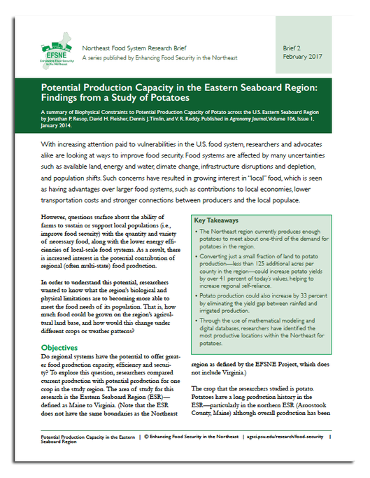
A summary of Biophysical Constraints to Potential Production Capacity of Potato across the U.S. Eastern Seaboard Region by Jonathan P. Resop*, David H. Fleisher*, Dennis J. Timlin*, and V. R. Reddy*. Published in Agronomy Journal, Volume 106, Issue 1, January 2014.
 A printer-friendly PDF version of this brief is available (970KB).
- The Northeast region currently produces enough potatoes to meet about one-third of the demand for potatoes in the region.
- Converting just a small fraction of land to potato production--less than 125 additional acres per county in the region--could increase potato yields by over 41 percent of today's values, helping to increase regional self-reliance.
- Potato production could also increase by 33 percent by eliminating the yield gap between rainfed and irrigated production.
- Through the use of mathematical modeling and digital databases, researchers have identified the most productive locations within the Northeast for potatoes.
*USDA Agriculture Research Service Crop Systems and Global Change Lab
With increasing attention paid to vulnerabilities in the U.S. food system, researchers and advocates alike are looking at ways to improve food security. Food systems are affected by many uncertainties such as available land, energy and water, climate change, infrastructure disruptions and depletion, and population shifts. Such concerns have resulted in growing interest in "local" food, which is seen as having advantages over larger food systems, such as contributions to local economies, lower transportation costs and stronger connections between producers and the local populace.
However, questions surface about the ability of farms to sustain or support local populations (i.e., improve food security) with the quantity and variety of necessary food, along with the lower energy efficiencies of local-scale food systems. As a result, there is increased interest in the potential contribution of regional (often multi-state) food production.
In order to understand this potential, researchers wanted to know what the region's biological and physical limitations are to becoming more able to meet the food needs of its population. That is, how much food could be grown on the region's agricultural land base, and how would this change under different crops or weather patterns?
Objectives
Do regional systems have the potential to offer greater food production capacity, efficiency and security? To explore this question, researchers compared current production with potential production for one crop in the study region. The area of study for this research is the Eastern Seaboard Region (ESR)--defined as Maine to Virginia. (Note that the ESR does not have the same boundaries as the Northeast region as defined by the EFSNE Project, which does not include Virginia.)
The crop that the researchers studied is potato. Potatoes have a long production history in the ESR--particularly in the northern ESR (Aroostook County, Maine) although overall production has been in decline due to a decrease in harvested areas. As a result, the ESR has relied more on importation to meet consumption demands, and currently produces only about one-third of the potatoes consumed in the region, assuming that 128 lbs of potatoes are consumed per person per year. Therefore, the potato is a good candidate to study the constraints on potential production for the ESR.
The study
Potential crop yield is defined as the maximum yield of a particular species under optimal management conditions, where stresses due to soil fertility, water availability, or pests and diseases are eliminated. Potential yield is then limited only by climate and the crop's genetic potential. While it is not realistic to achieve full potential under most field conditions, theoretical estimates can be useful to evaluate the potential production capacity for potato in the ESR. Crop models can be used to simulate this potential yield as well as the influence of stresses. Simulations from these crop models attempt to answer this question: what is the potential production capacity (in this case, of potatoes) under various scenarios. The researchers in this study modeled yield and resource requirements by developing a sophisticated new geospatial crop-modeling tool called Geospatial Agricultural Management and Crop Assessment Framework (GAMCAF). It divides the region into field-scale spatial units and combines layers of regional data--including historical climate, management, soil, and land-cover--with process-based crop models that simulate crop growth and development over the length of a season based on weather, soil, and management variables. Their ability to combine data from so many different sources allowed the researchers to simulate 30 independent growing seasons at thousands of unique field-sites over the entire Northeast for potato.
This crop-modeling tool enables the researchers to look at different scenarios of land use change, water availability, and climate change. For example, what would happen to production if growing season temperatures rise due to climate change? Furthermore, as other crops are added to the GAMCAF, researchers can compare how well various crops might perform in different areas of the region and under different management or climate-change scenarios. According to Dave Fleisher, lead researcher in this study, the tool can be used as "a way to optimize the spatial production of our commodities for our regional needs."
For this study, the researchers explored two scenarios. One looks at increasing production by increasing the land in potato production. The second examines the changes in production that may result due to shifting from rainfed to irrigated water management.
Findings
The researchers looked at agricultural land under potato production, and at all land in cultivated crops. The purpose of these designations was to simulate productivity in all ESR counties with existing production to compare with reported yield, calibrate or 'ground-truth' the models, and then estimate productivity in all counties where potatoes could potentially be grown. In the first simulation phase, researchers used the current land use scenario to establish baseline production capacity where potatoes are currently grown. The second phase simulated rainfed and irrigated management conditions across the entire ESR.
Based solely on land use classification, the study concluded that a large amount of land in the Eastern Seaboard is potentially available for potato production. A majority of the 102,000 acres in potato in the ESR (2007 NASS Census) is grown in 35 counties. Put into context, approximately 8.65 million acres of cropland is spread out across the whole ESR. If a small fraction of the potential area were converted to potatoes it could result in a dramatic increase in production capacity. For example, if each ESR county contributed an additional 123 acres to potatoes (including converting existing cropland), it would increase total potato production by 41 percent over today's current, or baseline, yields.
Other factors need to be considered. Natural limitations such as rocky soils and steep slopes may exist. It may not be economically practical to convert
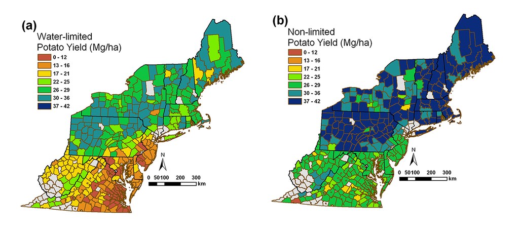
such land to potato production. Putting additional land area into production for potato would likely mean taking it away from that of another crop. And not all locations are equally suited to potato. Climate and water availability are major factors. As average seasonal temperature increases due to location, yield generally decreases, and production in southern states in the region also appears to be more limited by water availability.
In the second scenario--evaluating yield response to water availability--the researchers estimated that by eliminating the yield gap between rainfed or irrigated yields, potato production could increase by 33 percent over the baseline value. In general, yield capacity increases from south to north within the ESR as a result of cooler climates and higher rainfall. Based on unlimited water availability, and assuming no other considerations, the highest productivity was determined to be in northwestern Pennsylvania and Maine. Among the southern states, West Virginia--which is a cooler area of the southern portion of the ESR--showed the greatest potential for potato production. The researchers observe that with most current potato production occurring in the north, expansion into West Virginia could offer high-yielding local production for the southern ESR, and thus potentially could contribute to greater self-sufficiency.
The simulations (modeling) in this study were employed to evaluate the production capacity for potato in the ESR. The production scenario where plants were fully irrigated resulted in yields 33 percent above the baseline (current) yield. The second potential scenario assumed an increase in the total land area for potato production by converting an addition of about 123 acres to production in each county, adjusting for water limitations in the northern ESR. In this scenario, total potato production would increase 41 percent over baseline. In both cases, the potential production capacity increased to levels similar to those recorded in 2002 before the loss of potato land.
Conclusion
Both scenarios are within the realm of possibility and each has limitations. Eliminating the yield gap due to location, land availability, and water management would be difficult because management practices and cultivars are already optimized for growth and economic use of existing natural resources at most current production locations, leaving little room for improvement. Converting land into potato production may not be feasible in many areas. Potatoes cannot simply replace other crops or be promoted to do so without considering the impacts of such replacement. A more comprehensive approach needs to consider additional agricultural and socioeconomic factors such as yield simulations for other crops, dietary needs of the populace, and regional supply chains.
This research is a first step in evaluating the potential production capacity of the ESR. The geospatial model used in this study has many advantages over previous methods, but still carries limitations. Additional steps should be taken to advance this type of research and its usefulness to regional planners, policy makers and others. For example, additional crops could be included in the analysis to develop a "yield index." Such an index could be used when analyzing costs to optimize the regional production of food in a way that lowers transportation costs and increases profit to farmers, in addition to adapting to changing climate and water conditions.
Caption: Average potato yield assuming (a) water-limited and (b) nonlimited conditions for each county in the Eastern Seaboard region.
About the EFSNE project
The work described here is part of a larger research project called "Enhancing Food Security in the Northeast through Regional Food Systems" (EFSNE). From 2011 to 2017, the EFSNE project engaged more than 40 partners at multiple universities, non-profits and government agencies around the question of whether greater reliance on regionally produced food could improve food access in low-income communities, while also benefiting farmers, food supply chain firms and others in the food system.
EFSNE is supported by the National Institute of Food and Agriculture, U.S. Department of Agriculture, under award number (#2011-68004-30057) and is led by the Northeast Regional Center for Rural Development. Any opinions, findings, conclusions, or recommendations expressed in this publication do not necessarily reflect the view of the U.S. Department of Agriculture.
This brief was written and edited by:
- Kathy Ruhf, Northeast Sustainable Agriculture Working Group
- Kristen Devlin, Northeast Regional Center for Rural Development
- Kate Clancy, Food Systems Consultant
The authors acknowledge the contributions of Anne Palmer, Johns Hopkins Bloomberg School of Public Health, Center for a Livable Future.


